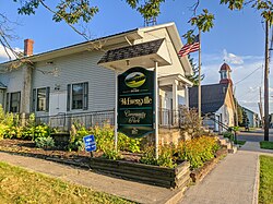
McEwensville, Pennsylvania
McEwensville, Pennsylvania | |
|---|---|
 McEwensville, Pennsylvania | |
 Location of McEwensville in Northumberland County, Pennsylvania. | |
| Coordinates: 41°04′20″N 76°49′07″W / 41.07222°N 76.81861°W | |
| Country | United States |
| State | Pennsylvania |
| County | Northumberland |
| Settled | 1825 |
| Incorporated | 1857 |
| Government | |
| • Type | Borough Council |
| • Mayor | Mark Moser |
| Area | |
• Total | 0.12 sq mi (0.30 km2) |
| • Land | 0.12 sq mi (0.30 km2) |
| • Water | 0.00 sq mi (0.00 km2) |
| Elevation [2] (center of borough) | 520 ft (160 m) |
| Highest elevation [2] (southeast boundary of borough) | 560 ft (170 m) |
| Lowest elevation [2] (tributary to Warrior Run) | 415 ft (126 m) |
| Population | |
• Total | 293 |
| • Density | 2,504.27/sq mi (967.10/km2) |
| Time zone | UTC-5 (Eastern (EST)) |
| • Summer (DST) | UTC-4 (EDT) |
| Zip code | 17749 |
| Area code | 570 |
| FIPS code | 42-46120 |
| Website | mcewensvilleboro |
McEwensville is a borough in Northumberland County, Pennsylvania, United States. The population was 298 during the 2020 census.
Geography
[edit]McEwensville is located at 41°4′20″N 76°49′7″W / 41.07222°N 76.81861°W (41.072139, -76.818719).[4]
According to the United States Census Bureau, the borough has a total area of 0.1 square miles (0.26 km2), all land.
Demographics
[edit]| Census | Pop. | Note | %± |
|---|---|---|---|
| 1860 | 301 | — | |
| 1870 | 269 | −10.6% | |
| 1880 | 326 | 21.2% | |
| 1890 | 262 | −19.6% | |
| 1900 | 208 | −20.6% | |
| 1910 | 209 | 0.5% | |
| 1920 | 207 | −1.0% | |
| 1930 | 210 | 1.4% | |
| 1940 | 261 | 24.3% | |
| 1950 | 297 | 13.8% | |
| 1960 | 795 | 167.7% | |
| 1970 | 247 | −68.9% | |
| 1980 | 247 | 0.0% | |
| 1990 | 273 | 10.5% | |
| 2000 | 314 | 15.0% | |
| 2010 | 279 | −11.1% | |
| 2020 | 293 | 5.0% | |
| Sources:[5][6][7][3] | |||
As of the census[6] of 2000, there were 314 people, 116 households, and 83 families residing in the borough. The population density was 3,272.9 inhabitants per square mile (1,263.7/km2). There were 123 housing units at an average density of 1,282.1 per square mile (495.0/km2). The racial makeup of the borough was 98.41% White and 1.59% African American. Hispanic or Latino of any race were 0.32% of the population.
There were 116 households, out of which 38.8% had children under the age of 18 living with them, 62.1% were married couples living together, 6.9% had a female householder with no husband present, and 28.4% were non-families. 21.6% of all households were made up of individuals, and 7.8% had someone living alone who was 65 years of age or older. The average household size was 2.71 and the average family size was 3.07.
In the borough the population was spread out, with 32.8% under the age of 18, 6.4% from 18 to 24, 29.9% from 25 to 44, 16.6% from 45 to 64, and 14.3% who were 65 years of age or older. The median age was 31 years. For every 100 females there were 92.6 males. For every 100 females age 18 and over, there were 95.4 males.
The median income for a household in the borough was $35,500, and the median income for a family was $39,250. Males had a median income of $28,125 versus $21,250 for females. The per capita income for the borough was $15,309. About 4.8% of families and 6.9% of the population were below the poverty line, including 3.2% of those under age 18 and 8.0% of those age 65 or over.
Education
[edit]McEwensville is served by the Warrior Run School District.
Government
[edit]The mayor of McEwensville is Mark Moser. McEwensville has a five-member borough council that meets the first Wednesday of each month at 7:00 PM unless otherwise noted. Council members are:[citation needed]
Mayor Mark Moser President Chris Walker Vice Pres. Fred Wesner Secy/Treas Rachael Sossamon Council Person Greg Yost Council Person Michael Romano Council Person Faye Arndt Shaffer Solicitor Robert Benion Tax Collector Jean Kline Smith Caretaker [Vacant] Code Officer CKCOG Permit Official CKCOG
References
[edit]- ^ "ArcGIS REST Services Directory". United States Census Bureau. Retrieved October 12, 2022.
- ^ a b c "McEwensville Topo Map, Northumberland County PA (Milton Area)". TopoZone. Locality, LLC. Retrieved 28 November 2019.
- ^ a b "Census Population API". United States Census Bureau. Retrieved Oct 12, 2022.
- ^ "US Gazetteer files: 2010, 2000, and 1990". United States Census Bureau. 2011-02-12. Retrieved 2011-04-23.
- ^ "Census of Population and Housing". U.S. Census Bureau. Retrieved 11 December 2013.
- ^ a b "U.S. Census website". United States Census Bureau. Retrieved 2008-01-31.
- ^ "Incorporated Places and Minor Civil Divisions Datasets: Subcounty Resident Population Estimates: April 1, 2010 to July 1, 2012". Population Estimates. U.S. Census Bureau. Archived from the original on 11 June 2013. Retrieved 11 December 2013.


